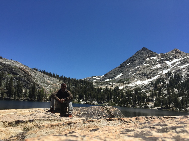
Crossing the abyss to Bigelow Lake
Emigrant
July 2016
It rained a bit on this trip but as I write
this, over 12 months on, I can't recall the
details. I've done my best to chronicle this
trip accurately. The Emigrant never disappoints.
This was a trip filled with the wonder of new
places, the danger of late season snow and the
excitement of fishing that only the Emigrant can
provide.
I left the familiar sights and smells of the Kennedy Meadows pack station unsure of my fitness and how I'd fair on a 6 day backpacking trip as I'd spent most of the spring ill. My sketchy history with this first accent meant that I was taking these easy. This first day would be a meander through Kennedy Meadows, up past Sheep Camp, over Brown Bear Pass, finishing at High Emigrant Lake if all went well.
Trips into the Emigrant are always interesting and this would not disappoint. Along the middle fork of the Stanislaus, before the first climb, I met an odd fellow. "That will be memorable." He said as I told him of my plans to take the trail from Snow Lake to Bigelow Lake. "Oh, it's got good fishing!?" I asked. "No" he said giving me a rather disgusted look. I made the first climb thinking what a strange encounter that was and wondering what he meant....
I've made and described this climb before. It's
a hot climb, even on cool mornings. From the
pack station you take a fire road to the
trailhead. The road skirts a meadow, then climbs
up to dirt lot scattered with fir trees, car
campers and horse trailers. This is where
I bivied many years ago when I made the decent
to the trailhead at 10:00 pm at night. I was
tired and weak with heat exhaustion. I found a
flat rock, laid out my sleeping bag and
collapsed. It's barely a mile from the trailhead.
From there
you climb to a bridge over the Stan and the
steepness begins. If you don't make this climb
before the rays of the sun reach it, it can be
unforgiving. From there the trail turns from
sand to large and sometimes uneven granite
slabs. A granite cliff to the right reaches out
over the trail like a giant hand reaching for
hikers as they pass by. When it's early, you are
tempted to stay under the shelter of the towering granite
face to
avoid the sun. Then you realize, "those large
rocks randomly scattered across the trail had to
come from somewhere" and you look up....
hugging the granite might not be the best course
of action.
At the top of this first section you cross
another bridge and then come to a fork in the
trail. Ahead is a granite shoot that many people
will ascend thinking it the quicker route. The
trail is actually to the right and is less
strenuous than the route directly ahead. I've
found no difference in the time it takes to
ascend either but a significant difference in the
effort required for both. Save the shoot for the
climb down.
Once past the shoot the trail begins to enter a
small grove of trees. You'll meet the the trail
to Kennedy Lakes here. Stay to your right. If
it's mid day, avoid the temptation to walk
directly up the trail, stay in the shade, the
more comfortable you can stay the better. Once
past the trees the trail opens up again, more
granite and sand and old mining equipment. The
trail can become confusing here but almost all
of the many offshoots end up back at the main
trail. Consult your map and keep and eye on foot
traffic in the sand to get through here. I've
made this trek many times and still
get confused through here.
Past this maze you come to the reservoir proper.
The trail is open and exposed and follows a
sheer granite cliff as it makes it's way down to
Grouse creek. The rays of the sun bounce off the
granite, making it doubly hot in the afternoon.
The creek is your best shot to fill up on water
between Relief Reservoir and Sheep Camp. There
are other water spots along the way but none as
reliable or easily accessible.
Passing the reservoir the trail meanders through
a pleasant wooded area before coming to the
junction to Relief Valley and heading up to
Saucer Meadow, Sheep Camp and Lunch Meadow.
Despite what it may look like on the map, Saucer
Meadow is not a place to camp. It's very tiny
and pretty much the center confluence of runoff
draining toward down the mountain.
The hike from the the trail junction to Saucer
Meadow is mostly granite horse steps and in the
spring will have run off streaming down. It can
be slippery and muddy as well as being steep and
tiring. At the top you get a great view of the
reservoir and surrounding peaks. Past this the
trail meanders once again, this time above
Summit creek.
About a mile past this point you'll find the
un-kept trails to Lewis lakes. The trail has
disappeared on many newer maps but enough people
still climb up the granite to the lakes that
there may still be trail ducks identifying the
route.
It seems like it takes forever to reach the
final climb to Sheep Camp. This is the first
significant landmark for me when climbing to
this trail. A half way point of sorts. A least
from a mental standpoint if in distance. Many
folks will chose this as a first night's
campsite. I've camped her twice. Once on a
solo trip up to Emigrant
Meadow Lake and again on a
return trip from Emigrant
with Roger. The fishing in the creek can be
good here.
From Sheep
Camp, Lunch Meadow is but a few miles
away and one makes the decision to travel over
Brown Bear pass, gateway to the upper Emigrant
or Mosquito Pass, which leads to Emigrant Lake.
This year I chose Brown Bear pass. My 6 day trip
would take me to High Emigrant Lake, Bigelow
Lake and Emigrant Lake. Camping a couple nights
at each and fishing in between as time allowed.
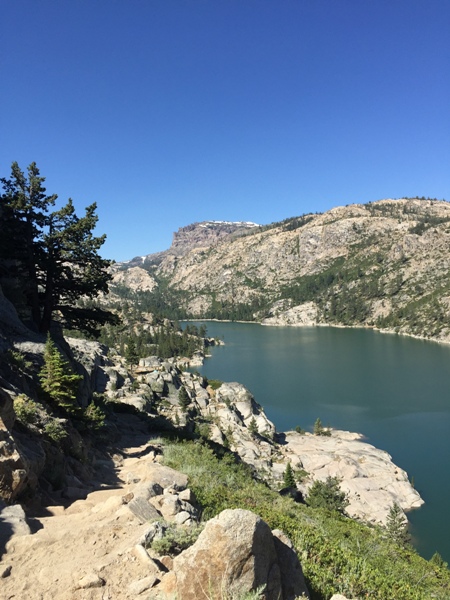
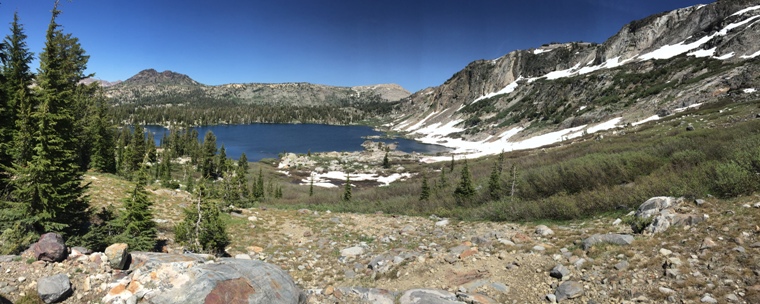
The view of Emigrant Meadow Lake from Brown Bear
pass has to be seen to be appreciated. Neither
my words nor my pictures do it justice. I made camp
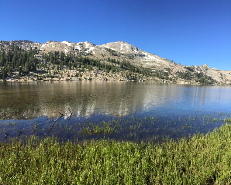
at High Emigrant in late afternoon. The lake was
full and the south eastern bank was still
covered with snow a few feet deep.
There was another group of folks camped on the
far side of the lake so I chose to camp in a
small depression near the incoming trail from Emigrant
Meadow lake.
The Anglers Guide to the Waters of the Emigrant
Basin lists High Emigrant as having Rainbow
Trout.
Roger and I were here 6 years earlier but
mother nature wouldn't allow us the time to fish
it properly. We were chased over Big Sam to the
lake by a violent thunderstorm and 30 minutes
after that storm passed, another started rolling
in. That storm followed us all the way to
Emigrant Lake but not before I was able to make
a few casts and get broken off by what I
presumed was a big rainbow trout.
For years, High Emigrant Lake and it's
large Rainbow Trout where unfinished business.
There were no fish rising that first evening so
I fished a, a black variant of the beadhead softhackle hairs ear that is my standard
prospecting fly. I rarely need it but it was the
fly that the fish broke off on that first trip
and it fortunately hadn't lost it's
effectiveness on these fish. I probably managed
to get into a half dozen fish that evening using
a deliberate approach and a slow strip, strip
pause retrieve.
The next morning I made my way west along the
southern shore sight fishing and prospecting.
Fishing was consistent for 13 to 15 inches Brook
Trout. Not the fish I expected to find. The lake
was more shallow along the north shore than on
the south, which made for exciting sight fishing
and gave up the largest fish in the lake.
The group on
the north shore left that morning and I spent a
quiet evening to myself at the lake.
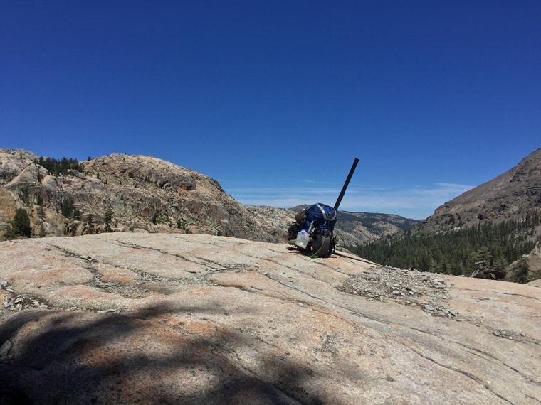
At day break I packed up and began the trek to
Bigelow Lake. Climbing up and over Emigrant Pass
I dropped into Grizzly Meadow. There are two
lakes in Grizzly Meadow, both of which are
supposed to hold fish. I made a mental note to
explore these lakes in the future.
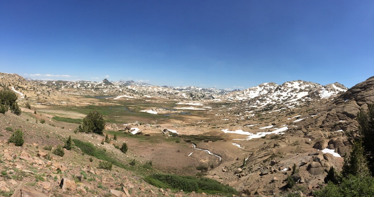
In the meadow the trail splits- a high road and
a low road of sorts. The "low" road leads to
Horse Meadow and the other to Summit Meadow.
Both can be taken to Snow Lake, which is where I
planned to catch the trail to Bigelow. The
"high" road seemed like the more direct of the
two. It was an extremely rocky
fire road (not unlike the trail from Horse
Meadow to Huckleberry) leading down to Summit
Meadow. Given the terrain, a trek through a
meadow would normally be welcome. Summit Meadow
however was wet and mashy with an excitable
mosquito population. I practically ran through
it to start the climb up the dry sandy trail
to Snow Lake.
I had planned to fish Snow Lake but after
reaching the lake and seeing the route I
had chosen to Bigelow Lake, I understood why the
character at Kennedy Meadows was so
.....strange. Snow Lake was large enough to be a
proper destination in and of itself. Its large
size and rocky shoreline would require a full
day to fish effectively.
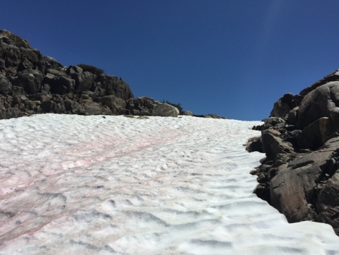
The trail to Bigelow was one long snow chute.
The trail lead me to the far side of the lake
where I saw a nice trout sunning itself in the
middle of the creek. After crossing the creek, I
followed it through a small grove of trees and
eventually lost the trail in some low brush. In
the low brush the trail simply became difficult
to follow but it was clear that it lead the snow chute. In retrospect, I probably
could have retreated, spent the afternoon
fishing Snow Lake and tried another trail into
Bigelow the following day but that thought never
crossed my mind. I had a plan. A plan that had
me going up and over that ridge and camping that
night at
Bigelow.
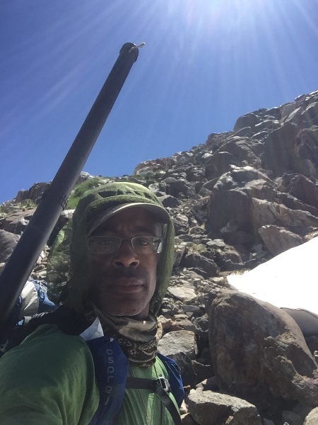
Without snow shoes and maybe an ice axe, I
couldn't follow the trail proper. I checked my
map and decided to ascend to the right of the
snow field. This looked like it would place me
on the top of the ridge in a section that,
looking at the contours on the map, would be a easy trek back to the trail.
It was clear that others had taken this same
route so I was confident. The climb was steep
but I was well within my comfort zone....until I
wasn't. I came to section, about 20feet long
and 35 feet or so from the top that seemed
impassable. It was 20 vertical feet of loose
gravel on a very steep slope. The larger rocks
surrounding the area were much steeper with
little or no hand and foot holds.
The pull to the top was strong but the thought
of navigating this section without a rope was more than a little freighting-
especially with a
pack on. If I'd lost my footing and my balance it
was a long rough tumble down to the lake. The
sections before this were tough and down
climbing would be difficult and not necessarily
safer.
I pulled out my Spot emergency messenger and
sent an "ok" message. If something went wrong,
someone would know my last location. I tossed my
trekking poles up the slope and scrambled on my
hands and knees after them. It was a strange
feeling, crawling up a mountain but it was
remarkably effective. I could feel gravity
pulling on my pack as I went.
The ridge was at top of a blade. That's what I
call rocky outcroppings that form a steep
ridge or multiple ridges without necessarily
being along the upper most portion of a
mountain. These ridges are often steep on both
sides and difficult to anticipate or see until
you are right up on them. Often times they are
ignored on a map because because the change in
height is negligible compared to the
surroundings.
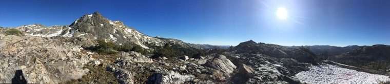
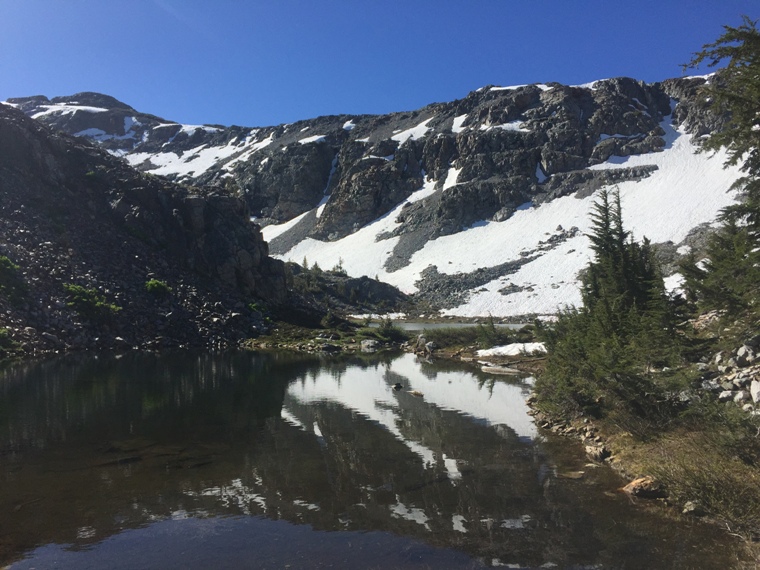
Between me and the trail, another blade and two small canyons with deep soft snow that would easily bury me with one misstep. I safely navigated each and found my way back to the trail. It was an hour or two after this that I made the final climb up to Bigelow lake.
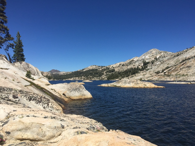
Bigelow is essentially two lakes separated by a
small channel. The north shore is surrounded by
scrub and ground cover while the south shore is
mostly rock. At the inlets and outlets, small
groves of trees. I decided to make camp in the
small grove of trees at the outlet. This was
close to the second lake, much smaller lake. The
smaller lake doesn't look like much on the map
and for most its probably an afterthought but
from my research, I believed it to contain
larger fish. That night I made a reconnaissance
trip to the second lake and then returned to the
main lake to catch a few fish close to camp
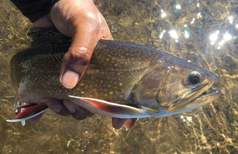
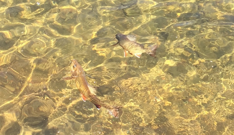
before dark. For the most part, chunky brook trout
came to hand.
The second lake was small and all but about one
third of the shoreline was accessible. The lake looked surprisingly barren- no fish rising,
no fish cruising, no fish coming to hand so
instead I worked my way down the channel back to
the main lake. I fished what shoreline I
could before concentrating on the main lake.
On the main lake,
I concentrated my efforts around the small point
where the lake met the channel. There was what
looked like an submerged weed bed about 35 feet
from the bank and when I managed to cast my fly
just over the weed bed and pull it into open
water, I was consistently catching fish in the
10 to 12 inches range.
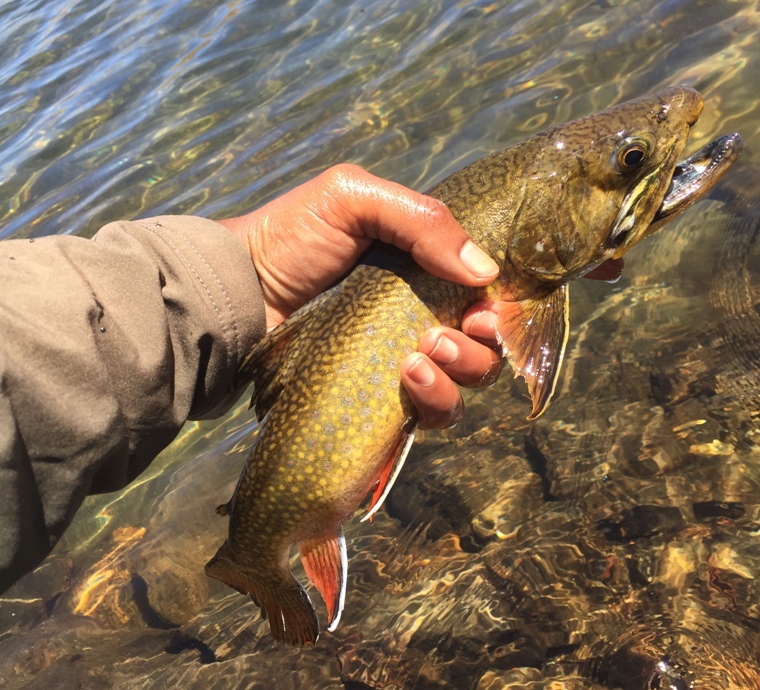
I typically fish a two nymph rig.
Usually a beadhead hares ear with a smaller
stillwater nymph or hares ear underneath. The
fish tend to prefer one or the other but in this
case, the brookies were taking either with equal
fervor. I was definitely working a pattern.
Based on where my cast landed, I could pretty
much predict whether or not I could catch a
fish. A bad cast was immediately followed up
with a longer roll cast to a slightly different
location. What I could not predict was
catching two fish on the same cast!
I worked this area for a couple of hours before
working my way around the rest of the lake. I
fished until early evening and found that
fishing was pretty consistent for brook trout in
the 10 to 12 inches range along it's entire
length.
That evening something large came crashing
through my camp. Likely a large deer but
whatever it was, it was heavy and in a hurry.
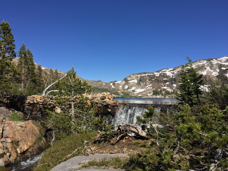
The next morning I made my normal breakfast of granola and a protein shake before tearing down camp and heading to Emigrant Lake. It's probably been a decade since I stopped carrying a portable stove. All my meals are cold.
The hike down to Horse Meadow from Bigelow is a steep one- incredibly so. So steep as to not be believed. Despite the switchbacks, this is one climb or in my case descent, that has to be experienced to appreciate. Steep and slippery from the rain early that morning, apparently there is no easy way to get to Bigelow Lake. I hiked down into Horse Meadow and over to Emigrant Lake.
I arrived at Emigrant just before dusk and once
again managed to secure my preferred camping
spot on the east end of the lake. The mosquitoes
at Bigelow were bad but it seemed like the
mosquitoes at Emigrant Lake were worse. They're
always bad here this time of year but it seemed
that this year was a whole new level. The water
levels were good and perhaps that little extra
meant a healthier mosquito hatch. What
mattered though is that those improved water
conditions (at least over the previous year)
meant the fish were pretty much where they were
supposed to be. When I approached the lake and
found fish were starting to stack up in the
inlet stream near the trail crossing, I knew it
was a good sign. The next morning I hoped to
find big fish cruising the flats.
I woke early the next morning, skipped breakfast
and headed straight for the shallow flats below
the outlet. From there I began working my way up
the outlet. This can be a funny place to fish.
Typically, as with any stream, it flows into the
lake but by mid morning the winds pick up and
force the water in the upstream direction, a
tough fishing situation if you prefer fishing
dry flies here, which I do.
That morning I was playing hide and seek with one particular fish. I had spotted it early but initially ignored it because it appeared small to me as it cruised the bank. I initially estimated it to be 12 or 14 inches. On many high country streams a 12 or 14 inch trout would be met with an immediate cast but on this lake, this time of year, this time of day.... I knew larger fish were possible and the fewer casts I made, the less I disturbed the water, the greater my chances of success.
I stalked the bank for 90 minutes looking for fish working the tall grass. I saw none. That first fish however had been cruising up and down the bank, in and out of casting range and eventually had taken a position below me. I'd watched it for well over an hour and knew it was only a matter of time before it swam back into casting range. I watched and waited and when it came into view, I cast down stream with a slight left mend into the main current and a slight drop of the line to induce slack.
My big black gnat floated slowly but the fish was actively moving upstream and intercepted it barely 15 feet into the drift. It was a confident rise. I whispered "got 'cha" to myself and then set the hook.
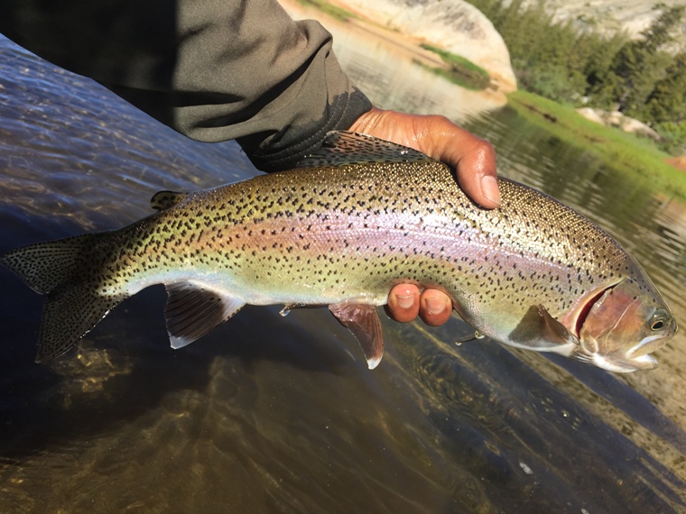
As I write this, I'm looking at pictures from this trip and walked into my garage to re-measure the witness marks on my fly rod- 20 inches. Imagine my surprise to land a 20 inches fish.....
Fishing improved as I made my way up the stream before crossing and fishing the south shore of the lake. I'd fished this lake several times and had never fished the south shore. Now that I've done so, I'll likely not fish it again. It starts out very promising near the inlet but shortly thereafter the terrain changes. It might prove to be big fish water late in the summer when the temperatures are high and the fish are in search of rocky shorelines with deep water but this time of year, I have no patience for prospecting over deep water when I know fish can be caught sight fishing with dries.
I saw few fish and as the shoreline approaches the outlet, the granite becomes very steep and difficult to travel. I took up the challenge to completely circumnavigate the lake and was forced to climb high above the lake over a very steep, slick slab. Then I had to climb higher still, around an impassable wall and then back down to the outlet. In the past I've found somewhat good fishing from the outlet, along the north shore, all the way back to camp and that was the case this trip.
I returned to camp just before dark and the next morning made the familiar journey over Mosquito Pass and back to Kennedy Meadows.